Saturday, December 20, 2014

Deep Creek Horse - Loop - Sunkota - Indian Creek - Deep Creek

Date: 12/20/14
Distance: 14.5
New Map Miles: 11.6
Total Map Miles: 713.4

Today's hike was an excellent loop hike in the Deep Creek area of the park.  It had a decent climb, some nice views, and three waterfalls.  It also had some crazy down and backs that only a map marker can appreciate.

The weather forecast for today had been 50% rain with snow at high elevations for most of the week, but by Friday it had improved slightly, so I decided to chance it and make the long drive to Deep Creek.  I left the house about 7:30 and was ready to hike at 10:00.  It was just misting by the time I started, so no rain gear was required.

I started by heading up the short access trail that leaves the Deep Creek Trail parking lot up to Juney Whank Falls.  Just a few tenths up the trail a sign was encountered that indicated the Horse Trail actually started 0.6 miles off to the left.  Being the anal map marker that I am, I turned left and hiked the horse trail down to the Noland Divide Trail.  At that point I turned around and backtracked.  The Horse Trail was in good shape, it worked its way up by Juney Whank Falls and then continued on up.  Just behind the falls, the trail turns right.  It is big and wide.  I don't know why I took the smaller trail to the left, but after a few tenths of a mile I decided that I was lost and I turned back and followed the wide trail.  The Horse trail meets up with Deep Creek after 2 miles.

Deep Creek is nearly flat from the parking lot to that location, but the Horse trail goes up and over a ridge. Deep Creek is a gravel road on this section.
 After 1 mile on Deep Creek and just after you cross this bridge, it is time to turn right on the Loop Trail.

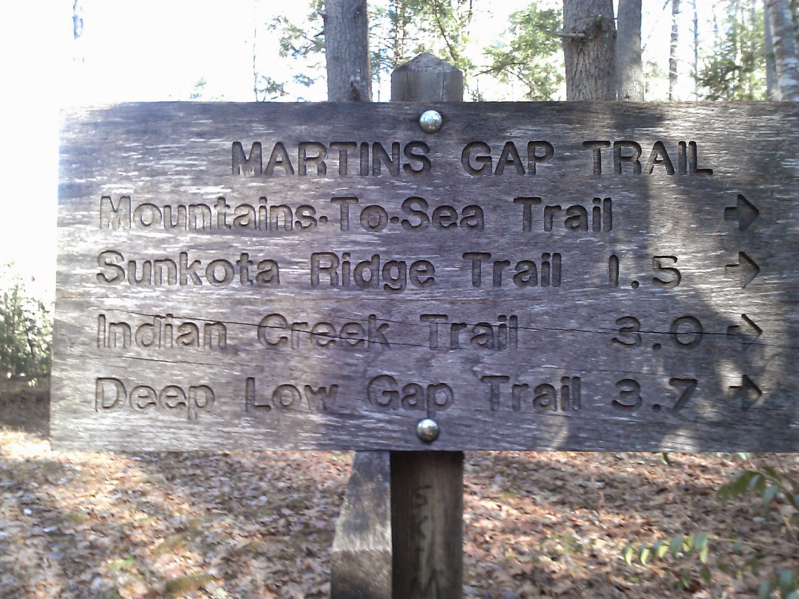
The Loop Trail is a 1 mile trail that is bisected by Sunkota and ends at Indian Creek.  I hike the entire 1 mile to Indian Creek and then backtracked once again to the Sunkota Trail.  It does have a nice climb up to Sunkota and then a drop in elevation down to Indian Creek.  I was dreading the walk back up all of the way down to Indian Creek, but a Map Marker has to do what a Map Marker has to do.


Sunkota was an awesome trail that follows a ridge up the mountain.  Nearly all of the trail is on the ridge or just off of it.  It does have a 1700' climb over the 1st 3 miles with some of that elevation lost over the next 0.8.  The trail surface was great with few rocks and no muddy spots to speak of.

 A mile or so into this leg of the trail, I hiked into the clouds which made things a little eerie.  Had it been sunny, I imagine there are some nice views off both sides of the trail through the trees.  In the summer, I doubt there are many views.


At one point, I looked up and spotted a buck standing in the trail. I expected him to run as I approached.


 I kept getting closer, but he wasn't moving.  I was much closer than the pictures imply.  Those antlers looked pretty intimidating.


Finally after I watched him for a couple of minutes from behind a tree, I made some noise and banged my sticks together.  He didn't budge, so I waited a little longer.  Finally after another minute or 2, he ambled off to the side and I scurried on by.


After 3.8 miles on Sunkota, I reached Martins Gap Trail.  This trail also connects Deep Creek to Indian Creek and is bisected by Sunkota.  I had previously hiked the section from Deep Creek to Sunkota, so today I just turned right to hike the leg toward Indian Creek.


Martins was in poorer condition than Sunkota.  It was rocky in places and muddy in others.  The Log bridge left something to be desired as well.

 After 1.5 miles, I reached Indian Creek.  Where Martins hits Indian Creek, Indian Creek has a loop which makes you wonder which way you should go, but it is just a turnaround and either will work.

Indian Creek is also a gravel road, so the hiking wasn't very exciting.

There is a nice cascade down near where the trail hits Deep Creek.


On down Deep Creek a waterfall (Toms Branch) pours into Deep Creek.


To finish off the day, I turned right on the Juney Whank Trail to go by that waterfall on the way out.


Wednesday, December 17, 2014

Newton Bald + Oconaluftee River Trail

Date: 12/17/14
Distance: 12.6
New Map Miles: 6.3
Total Map Miles: 701.8

This Wednesday I took 1/2 a day off and collected a few new map miles.  The sky was cloudy and it was a little cold in Knoxville, but by the time I got to the Smokies, it was clear and felt warmer.  I started today with the Newton Bald Trail which starts just across from Smokemont.

Newton Bald was a very well graded pleasant trail to hike even with a climb of nearly 3000'.  The 1st 0.3 miles was very wide but at that point, the trail became the classic Smokies trail.


 The sky was beautiful today.

 There were awesome views through the trees today.

 At 4.7 miles on the sign (4.8 on the spreadsheet) I reached the end of the portion of the trail I needed so I turned around and headed back to the car.


 On the way up, I had spotted the knob in the following picture and wondered if that was the "bald".  Turns out that it was.  It is no longer a bald, but the knob just looked like a good place for a bald.


 After I got to the car, I still had a little time, so I drove down to Oconaluftee to get the 1.5 mile river trail.  The trail is wide and smooth and graveled.  It hugs the river from the Oconaluftee visitor center to Cherokee.  It ended at the 1st traffic light in Cherokee.


Saturday, December 13, 2014

Deep Creek - Martins Gap - Sunkota Ridge - Thomas Divide

Date: 12/13/14
Distance: 20
New Map Miles: 18.9
Total Map Miles: 695.5

Today was a very productive day on the map.  I gained 18.9 miles and only had to hike 20 to get it.  I left my car at Thomas Divide where it hits 441 and Russ drove us up to Deep Creek.

The Deep Creek Trail starts with a steep downhill section as you leave 441, but eventually levels out enough to be very pleasant.  There were several small creek crossings which we rock hopped, but it took a little effort.  Nearly all of the trail was within site of the creek with a few spots where you are very close to the creek.  I could imagine that the trail could flood out in a high water event.


After about 8 miles we reached the Martins Gap trail.


There was a nice campsite where Martins Gap turned to the left, so we sat for a short lunch.  The site was in the shade so we quickly got cold and decided to get moving.  Martins Gap was only 1.5 miles, but had a big elevation gain.  At the Gap, it was time to remove the long johns, fleeces and gloves as the rising temperatures of the day and the steep climb combined to start the sweat flowing.

At Martins Gap, we turned left onto Sunkota Ridge Trail.  the climb continued on Sunkota, but at a lesser slope than on Martins.  Sunkota was 4.9 miles out to Thomas Divide.


 At Thomas Divide, I turned right to get the small spur down the the Newton Bald Trail.  This spur was 0.4 miles one way.  Russ headed on up Thomas Divide as he didn't need this piece.  The 0.4 mile section had a good climb that I immediately lost when I reached the intersection and headed back.  After completing my 0.8 mile detour, I headed on up Thomas Divide toward Kanati Fork.

 This portion of the hike had what felt like a big decline in elevation, before heading back up to our highest elevation of just over 5000'.  This portion of the hike was tough.  I wasn't prepared for much of a climb on this section as I had been fooled by the elevation chart in the brown book.

There were some nice views through the trees of Clingmans Dome and there were a few areas with snow where the sun doesn't shine.


I was also surprised that there was a nice downhill section just before getting back to 441.  The hike took a bit less than 7 hours including breaks, so we were back to the car at 4:15.  Traffic was reasonable and I made it home by 6:15 including a stop a Gondolier for a plate of Spaghetti.