Tuesday, May 31, 2016

Bradley Fork – BMT Connector- Road to Towstring – Towstring – Bradley Smokemont Loop

Date: 5/29/16
Distance: 10 miles

Bill and I hiked these "garbage" trails to finish off the Memorial Day GSHAG Fall Campout.  These trails are nothing special, but they are on the map, so I must hike them!

We started at the back of the Smokemont Campground.  We took the short walk up Bradley Fork to the BMT connector.  We took the BMT connector back down to the Church at the front of Smokemont.

From there we walked down the road to the stables and then continued on the gravel road to the Tow String Trail.

We followed the Tow String trail back to Bradley Fork where we turned right and walked about 1.2 miles up to the Smokemont Loop Trail.

Smokemont Loop Trail was the pits.  The climb seemed horrific for a trail that doesn't really go anywhere.  I had already hiked the 2 previous days and spent the night it the campground for 2 nights.  I'm sure that contributed to the dislike.

The Loop Trail brought us back to the campground where we finished the hike.


NFG to Smokemont campground (AT-Dry Sluice – Cabin Flats – Bradley Fork)

Date: 5/28/16
Distance: 13.7

This GSHAG hike was from Newfound Gap to the Smokemont campground via the AT, Dry Sluice and Bradley Fork.  We also took a short in and out side trip to Cabin Flats along the way.  JD, David, Mary Anne and Jack hiked the entire hike.  About 7 other hikers opted for the shorter version returning to NFG from the Bunion.

The highlight of the hike was Charlies Bunion.  Unfortunately my phone was out of whack, so the pictures weren't great.


 I found this picture on the hike the Smokies Facebook group.  I'm the guy in blue on the high rock to the left.


 Dutchmans Pipe on Dry Sluice.


900 miler x2 (Mingus Creek - Newton Bald - Thomas Divide - Cooper Creek)

Date: 5/27/16
Distance: 17.3 miles

Today's hike represents the final hike to finish up my 2nd lap around the park.  I'll start with the hike and finish up with a few comments about my 2nd map.

We started the hike at the Mingus Creek Trailhead which is just up the hill from the Oconaluftee Visitors Center.  Today I hiked with JD, Anoria, Chris, Craig, Lane, George, Gil, Suzanne, Paula and Angie.  Mingus Creek is 5.7 miles long with a rather large climb from about 2000' to 5000'.  It begins as a gravel road but turns into a single track trail after a mile or so.

Mingus Creek merges with Newton Bald which we followed for 0.7 miles to the Thomas Divide Trail.  We followed Thomas Divide down the mountain for 3.1 miles before we reached the Deeplow Gap Trail where we stopped for a rest and a bit of lunch.  We had dropped down to 3700' at this point.

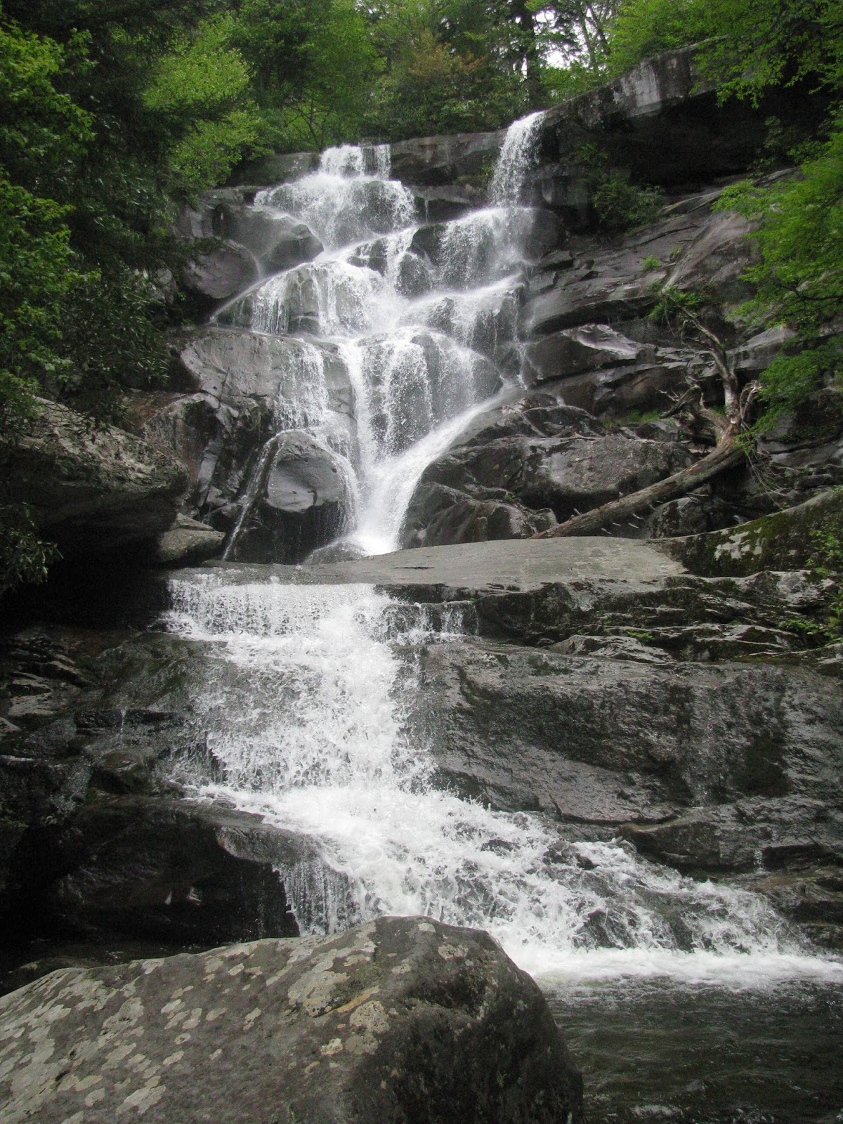
After lunch we started down the Deep Low Gap.  Not far down the trail it started raining and before long it was pouring.  There is a very scenic waterfall on this section of the trail, but it was raining hard, so no one bothered with their camera.  It was quite nice though.

After 1.5 miles on Deep Low Gap, we arrived at the Cooper Road Trail. It is a 0.5 mile nasty, wet gravel road.  It was still raining, so it was more wet than usual.  After 0.5 miles we arrived at the gate across the road which we touched before returning to Deep Low Gap.

We continued on Deep Low Gap for 2.4 miles back to Mingus Creek.  The climb was about 1100'.  At the Mingus Creek Trail, my 2nd map was complete.  Thankfully the rain had stopped, so we stopped for a bit of a ceremony before the 2.9 mile hike back down Mingus Creek to the car where we had a celebratory brownie to finish off the day.


900 Miler x2 

As I mentioned above, this hike finished off my 2nd "map" of the park.  The 900 mile club consists of people who have hiked every trail in the park.

Stats

Date of 1st hike: 4/4/15
Date of final hike: 5/27/16
Number of hiking days: 82
Longest Hike: 25 (NFG to Snakeden to Cosby)
Total Miles hiked to finish: 1196.4
Nights spent in the woods: 5
Number of Solo Miles: 600.7

Musings

I didn't start this lap around the park with any speed goals in mind, but by about 7 months, a goal of 14 months was bouncing around in my head.  I was super fortunate that many hikes worked out (sometimes miraculously) and I finished about 1 week ahead of goal.  I was super pleased to beat my goal.

Some hikers dislike or fear hiking alone.  I've never suffered from that fear.  I enjoy hiking alone and I enjoy hiking with groups.  I started this map with the goal of hiking with other folks more than the last one.  I can't say that I achieved that goal since slightly more than 1/2 of my miles were solo.   In the end, I'm not too upset with the mix.  I can't think of a single hike in which I arrived back at home wishing I had handled it differently.  One thing I did enjoy was finishing with a good sized group.  The congratulations and camaraderie made the day extra special.

I'm not even going to attempt to deny that I'm not working on map #3.  It is just what I do.  Let's go hiking...


Tuesday, May 24, 2016

Cucumber Gap - Little River

Date: 5/24/16
Distance: 13.4 miles

Today I hiked the Cucumber Gap and Little River Trails.  This hike was exactly the hike which I described in a previous post.

http://rustyhikes.blogspot.com/2015/03/cucumber-gap-little-river.html

Today the creek levels were relatively low so I was able to rock hop all of the creek crossings with ease.  The trail was starting to get overgrown from Rough Fork to campsite 30.  I was pretty tired of weeds rubbing against my legs on that section.


Cucumber Gap Trail

Lower section of Little River Trail

Campsite 30

Creek Crossing at Campsite 30


The hike has relatively little elevation gain, so I was able to make good time today finishing in 3:36.


Sunday, May 22, 2016

Ramsay Cascades

Date: 5/22/16
Distance: 8 miles

Today it was great to hike with my son Nathan on the Ramsay Cascades trail.  The Ramsay Cascades trail is located at the end of the road in the Greenbrier Section of the park.  Much of the drive is on a narrow gravel road,

The trail starts with a large bridge across the creek before it starts up the mountain on an old gravel road for the 1st 1.5 miles of the hike.


 At that point the trail becomes a classic single track path through the woods.  The 1st log bridge was long and pretty bouncy.
 About 2.5 miles from the car is a Huge tree.


 The trail rather steeply worked its way up the mountain.  There were a number of sections that were quite rocky and rooty.  There were also a few flowers about.


 The waterfall is very impressive.


 After a short break and some lunch, we headed back down the mountain.


This hike is short, but still strenuous as it climbs more than 2000' over its short distance.  The payoff is big on this hike with the waterfall, large trees and creek views.