Saturday, March 26, 2016

Sugarland Mountain - AT from Clingmans to Sugarland

Date: 3/26/16
Distance: 16.4 miles

This winter has been rather mild and as a result the Clingmans Dome road opened a week early.  Russ, Chris and I took advantage and shuttle hiked the Sugarland Mountain Trail today.  I met Chris and Russ at Fighting Creek Gap where we piled into Russ's car.  About 30 minutes later, we arrived at the Fork Ridge Parking area.  A short access trail across the street from the Fork Ridge Trail took us over to the AT, where we turned left and walked 0.2 miles over to the Sugarland Mountain Trail.

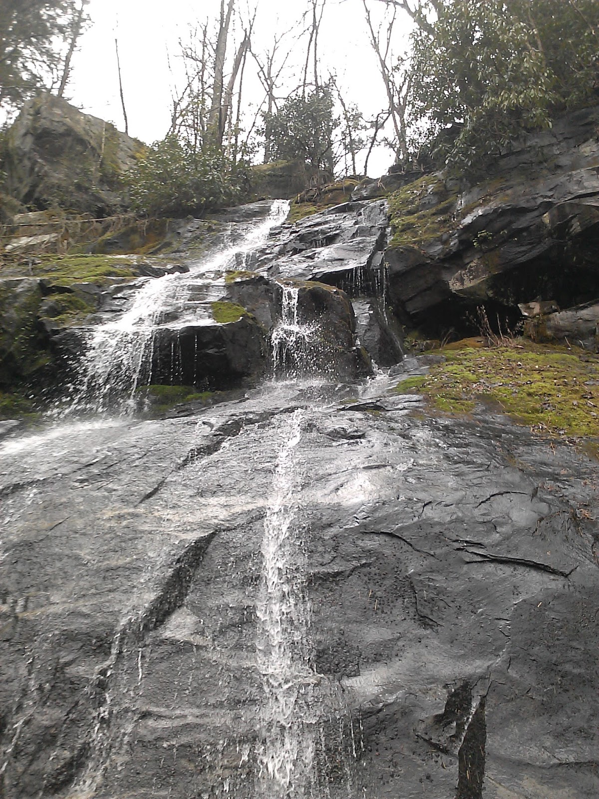
As you would expect, Sugarland Mountain loses lots of elevation (3700') over its 12 miles.  Surprisingly it also has several short uphill sections.  The day was very beautiful and the trail was very nice.  Much of it is close to the ridge.  There aren't many views along the trail, but there are a few spots where you can catch glimpses of Gatlinburg down below.

 What looks like a small bump down at the end of the hike seemed extra steep, but now that I see the graph it is almost embarrassing that I thought it was so tough.  Chris and Russ got motivated to get out before 12, so we moved out on this hike finishing up in a bit less than 4 hours.

I drove Russ back to his car on the Clingmans Dome road.  He offered to run me up to Clingmans Dome so I could solo hike the AT from Clingmans back down to Mt Collins where my car was positioned.  I took advantage to do a bit more hiking.

At the Dome, I went up the paved trail and took a few photos from the tower.


It was pretty cold on the tower, so I took off down the AT pretty quickly.  I was disappointed to then learn that my lunch wasn't in my pack.  I had left it in my car while rearranging my pack before going up to the Dome.   Fortunately the hike to the car was only 3.5 miles.  The thought of arriving at my car and eating my lunch was my motivation.

Surprisingly there is a rather large climb on this section of the AT.  From the tower, the trail loses about 1000' and then gains 1/2 of that back before the final downhill section the the car.  The trail is quite rocky with lots of "stairsteps", so the hiking wasn't too speedy.


Snake Den Ridge - Maddron Bald - Albright Grove Loop - Gabes Mountain

Date: 3/25/16
Distance: 18.7

My Good Friday hike this year was a really long, hard, but enjoyable loop hike in the Cosby area of the park.  I started the day by hiking the first 4.6 miles of Snake Den Ridge Trail leaving from the Cosby Campground.  It took a bit of a walk and a little searching to locate the trail, but after about 10 minutes and 1/2 mile, I found it and headed up the trail.  Today I walked in the clouds for much of the day.


Snake Den climbs about 3000' in its 4.6 miles, so it was no easy start to the day.  About the time I reached Maddron Bald Trail, the sun started peeking out.
 I turned right on Maddron Bald Trail and started descending.

 There were a few nice views through the trees.

 The bald was covered with bushes, which gave a few more views of the surrounding mountains.


 The Sun was nice, but didn't last long.  About 1 mile down the trail, I was back in the clouds.
 Maddron had a little bit of everything.  There were places that the trail was quite nice.  Others were very rocky.  It did have 3 or 4 decent size creek crossings.  I hopped them all, but it took a little work.
 The foggy day made the trail a little spooky.

 4 miles down the trail is the Albright Grove Loop. The Loop is 0.7 miles long and passes by some large trees.  The trail goes up and over several small ridges as it twists and turns on the side of the mountain.

 Albright returns to Maddron Bald 0.3 miles below where it started.  I walked back up the hill to where I left Maddron and then turned around and hiked another 2 miles to Gabe Mountain Trail.  The lower portion of the trail had bridges over the creek, so the hiking was pretty easy.
 Maddron lost about 3000' over its 6 miles.

I turned right on Gabes Mountain Trail for the final 6.6 miles back to the car.  Gabes gains and loses about 1000', so it did require some exertion.  4.4 miles down the trail is the spur down to Henwallow Falls.  The trail to the falls is pretty steep as it makes its way down to the falls and is maybe 0.2 miles long.

The falls is rather tall and doesn't have much water flow, but it is quite beautiful.


 After a few minutes at the falls, I climbed back up to Gabes Mountain and hustled down the trail for the last 2.2 miles.

This loop hike is very long and strenuous, but it is a really good way to mark off this group of trails with only one trip to the mountains.

The GPS had a hard time locking, so no elevation data today.

Saturday, March 19, 2016

Deep Creek odds and ends

Date: 3/19/16
Distance: 19.8

Today my map marking fever took me over to Deep Creek to get a few odds and ends on the Deep Creek Trail.  It would have been much better to find a shuttle partner and hike the entire trail, but that requires planning and organization.  I'm more of a just get up on Saturday morning and go hiking kind of guy.

On map #2, I needed the 4.3 miles from the Loop Trail up to Martins Gap, the short distance from the horse trail to Indian Creek, and the 3.9 miles from 441 to Fork Ridge.  I determined that today was the day to finish up these pieces.

I started the day by driving over to Deep Creek (2:30) and hitting the trail about 9:45.  The low section of Deep Creek is a road, so the hiking is easy.  There is a nice falls about 0.25 miles from the parking lot.

 At one point, a park service vehicle went driving right by me on the trail.  That just didn't feel right.

About 2.25 miles into the hike, the trail has a large loop in it.  I got so distracted by the loop, I missed the trail leaving off to the right.  In the picture below, you can see that that the trail appears to go straight, but the little sign off to the right points in the right direction.  I circled the loop and couldn't figure out where to go for a few minutes, but I finally spotted the sign and took off up the trail.  From this point the trail is more of a typical Smokies single track trail.
 
The trail goes up and over a few hills, but only gains about 600' up to the Martins Gap intersection where I turned around (6 miles in)
 I found a friend on the way back down.  I gave him some space and he eventually moved back off of the trail.

 Deep Creek has lots of water features to keep your eyes entertained.


 I covered the 12 miles in 3:28.  This trail is easy to hike fast.

 I dumped my stuff in the car and took off for the other end of Deep Creek up at 441.  About 1 hour later, I arrived at the other end of Deep Creek.  This end of Deep Creek is very steep.  The  1st mile of the trail is very steep with lots of switchbacks.  The trail is very smooth in this section with hardly any rocks or roots, so I was moving quickly.  It had starting to drizzle a bit, so I left my phone in my pack, so no pictures on this one.

After the 1st mile, the trail drops down into the creek region which is less steep.  This portion of the trail has several sections where the trail and the creek become one.  It was no big deal to hop rock most of it.

I made it to Fork ridge in 1:06, but I had lost nearly 1800'.  The hike back up to the car wasn't going to be near as fast.  I still managed to hike up the hill in 1:27, so I was pretty happy with my total time.  Back on the switchbacks, I saw a very small bear standing in the trail which was a nice way to finish off the trail.

Sunday, March 13, 2016

Laurel Gap Backpack Day 2 - Balsam Mtn - Gunter Fork - Big Creek

Date: 3/12/16
Distance: 21.4 miles

After a night of tossing and turning, we packed up and left the shelter about 7:40.  We hiked the 1.2 miles from the Shelter over to the Gunter Fork Trail and I had a decision to make.  The group plan was to just hike down Gunter Fork to Big Creek for a total of 11.6 miles, but I really wanted to hike the portion of Balsam Mtn from Gunter over to the AT.  This is a hard section to hike because it is 4.9 miles long and is 10 miles from anywhere.  The trail is fairly flat, but if I decided to hike it I was looking at a 21.4 mile day.  I was feeling pretty good that morning and the pack wasn't feeling horribly heavy, so I said so long to my hiking partners and headed for the AT.

Balsam Mountain trail didn't feel quite as flat as the Brown Book would indicate, so the 4.9 mile walk over to the AT was a little more difficult than I expected, but it is a really pretty section of trail.  Most of the trail is in a Fir forest.  Much of the trail is covered with pine needles and is easy to hike, but there are also sections that are very rocky and rooty.

 Sometime you walk by stuff on the trail that just makes you go Huh.

 I made it out to the AT in about 2 hours (from the shelter), took a picture of the sign and quickly turned around for the 4.9 miles back to Gunter Fork.
 Balsam had quite a few trees laying in the trail.
 There were some really nice views through the trees, but they don't show well in photos.


 Back at Gunter Fork (11 miles into the day), I took a short break and ate some lunch before heading down the mountain.  Gunter Fork can be dangerous if it has rained recently, so I was glad that today was only cloudy and not rainy.
 The top of Gunter is often narrow and it feels as if it would be easy to misstep and slide down the side of the mountain.  It was also fairly overgrown even though the leaves weren't out on the plants yet.

There is one area on Gunter where a landslide has wiped out the vegetation.  It is about 50' across.

Gunter has a few nice views on the way down the mountain.


 The creek crossings weren't unreasonable on this day.  I was able to rock hop each of them.  There were about 7 crossings in all.  The last couple are the largest as you would expect.
 There is a really nice cascade about 1/2 way down the trail.

This is another of the creek crossings.
 When the trail isn't crossing the creek, it is right along the side of it.
 This is the final crossing.

 About 4 miles and after a drop of 2200', I was very happy to see the sign indicating that I had reached the Camel Gap Trail.
 I turned right on Camel Gap which changes to Big Creek after 0.6 miles.  From here it was a 5.7 mile walk down the old road which is Big Creek to the car.

I had done a good job of keeping up my pace on this long day and was just 5 minutes short of a 3 mph pace.  I was "smelling the barn", so I picked up the pace and headed down the trail.

I did stop for a couple more photos and I enjoyed chatting with all of the day hikers that I passed by  on the trail.


I made it to the car by 2:35 for a total hiking time of 6:55.  I was feeling really good on this day and was very happy that I made the decision to hike the extra mileage.  I'm sure the lack of significant climbing helped the pace.