Saturday, January 9, 2016

Grapeyard Ridge - Baskins Creek - Trillium Gap - Old Sugarlands

Date: 1/9/16
Distance: 18 miles

Today I shuttle hiked with Russ and Darrell.  We met at Sugarlands Visitor Center at 8:30.  We left one car there and piled into another for the drive to the Grapeyard Ridge Trailhead in the Greenbrier section of the park.  We started hiking about 9:00.

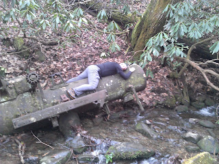
Grapeyard is 7.6 miles in length.  It is a very nice trail with very few rocks and roots.  It does have a few small stream crossings that I apparently struggled with the last time I hiked it, but today I don't know why.  We hopped them all easily.  The most famous feature of Grapeyard is the steam engine in the creek.  We spent some time checking it out.


 Grapeyard has several ups and downs.  It does climb a fair amount (about 2600').  The trail ends on the Roaring Fork Motor Trail.  There are several historic structures where the trail ends.


 We crossed the road and ate a little lunch before continuing the hike on Baskins Creek Trail.  Just a few yards down the trail is a Cemetery.
 About 1.5 miles down the trail is a sign that points toward the falls.  It is about 0.2 miles down the mountain.  It is a little steep and muddy down to the base of the falls.


 After a few minutes at the falls, we hiked back up to the Baskins Creek Trail and continued toward Trillium Gap.  There were a couple of spots in this section with a few views.  It was a pretty good climb up Baskins to Trillium Gap Trail (about 800').  Baskins crosses the road and then dead ends into Trillium Gap Trail.  We turned right and walked 0.6 mile on Trillium to the Old Sugarlands Trail.

 Old Sugarlands covers 3.9 miles back to 441 near the Sugarlands Visitor Center.  About 2.5 miles down the trail is the manway over to the Stone House.  Since we had some time, I took the guys over to see it.  I was thinking it was about 0.5 miles to the house, but it was actually about 1.2 miles with a climb of about 500'.


 We returned back the way we came to Old Sugarlands and hiked the final 1.4 miles to 441.  We were wishing that we had moved the car closer to the trail as the walk over to the visitor center felt a little long late in the day.

For a low elevation hike, we climbed a surprising amount, but it was nice to cover a long distance with some good friends.

Saturday, January 2, 2016

Cove Mountain - Laurel Falls

Date: 1/2/16
Distance: 13

This hike is a very nice shuttle hike that is close to Gatlinburg.   It was nice to hike with Russ and Bill on this day.  I met Russ at the Laurel Falls trail about 8:45 where we left a car before driving over to the Sugarlands Visitor Center to meet Bill.   We got ready to hike rather leisurely hitting the trail about 9:15.

We started by leaving on the sidewalk behind the visitor center and then taking the Nature Trail over to Cataract falls.  The nature trail added about 0.5 miles to the hike.  We could have driven around and parked closer to the trailhead, but it was an easy walk over.

Cataract had a decent amount of water on this day.


 Cove Mtn is 8.5 miles up to the Cove Mtn fire tower.  The trail is wide and smooth and easy to hike, but it climbs about 3000', so it is a workout.  There are a few places with some views.

 The trail goes by several houses and Ober Gatlinburg as it makes its way up the mountain.  We made good time up to the tower covering the 9 miles from the visitors center to the tower in only 3 hours.  The tower is used by TVA and the Park Service to monitor pollution and weather, so it isn't accessible to hikers, so there are no views at the tower.

From the tower, we backtracked 0.1 miles to the Laurel Falls trail.  We hiked it for 0.9 miles to the Little Greenbrier intersection where we stopped for some lunch.

From there it was only 3.1 miles to the car.  The Falls was about 1/2 way down the trail.  It was packed with people to the point that it was kind of miserable.


We didn't stay long at all before heading down the paved trail to the car.  I don't know why they paved it.  The pavement is pretty rough.  It would have been much better to just "pave" it with small gravel or something like that.

There are a couple of nice view locations on the walk.

 We passed about 100 "hikers" over the last 1.2 miles to the car.  In hindsight, I wish we had hiked the other way as the crowded part would have been in the morning when fewer tourists were clogging the trail.  The climb would have also been shorter.

Friday, January 1, 2016

Middle Prong - Panther Creek - Miry Ridge - Lynn Camp Prong

Date: 1/1/16
Distance: 15 miles

I got the new year off to a good start with a nice "lollipop" hike in the Tremont area of the park.  This is the same hike that I did October 2013 except I hiked the loop in the opposite direction.
MiddlePantherMiryLynnCamp

This cascade is about .5 miles from the trailhead.


 I found the old car again off to the right of the trail just out of sight.

 With all of the rain last week, I wasn't able to rock hop the creek at the beginning of Panther Creek.  It was quite cold today and the water was a bit more than knee deep.
 Panther Creek climbed up the mountain very close to the creek for most of the trail.  The trail was a bit rocky and mushy in places.

At the Miry Ridge trail, the creek was left behind and some views started showing through the trees.

 The highest elevation (4700') is reached about 1 mile up Miry Ridge.  There is a spot that opens up to give some really nice views.


From the peak elevation, the rest of the hike is downhill (2nd half of Miry, Lynn Camp and Middle Prong).  I turned off of the Miry Ridge trail when it intersected the Lynn Camp Prong trail.

On Lynn Camp and Miry there were a few rock hop opportunities.
 As I lost elevation, I dropped back into the clouds giving a haunted forest effect.
 Lynn Camp hits Middle Prong after 3.7 miles.  Just 0.2 miles down Middle Prong, a small side trail goes over to Indian Flats falls.


 I crawled down through the Rhododendron to the third step of the falls.  It is actually 4 falls in succession.


It was about 4 miles from the falls back to the car.  Middle Prong is a gravel/rocky road, so the hiking isn't that great.  There are some old artifacts around to keep you entertained though.

 I like this hike because it has lots of variety:  Creek hiking, creek wading, old artifacts, some views, a big climb (3000'), and a nice Waterfall.