Monday, June 9, 2014

Shining Rock Backpack

Date: 6/7/14 - 6/9/14
Distance: ~17mi

This weekend I was the tag along Dad on a backpack trip with my son and his friends in the Shining Rock Wilderness in Western North Carolina.

We parked on the side of the road half way down the Black Balsam Knob Road which is off of the Blue Ridge Parkway.  The trail was the "Art Loeb" Trail.  This is a fine group of men who accompanied me on the hike.

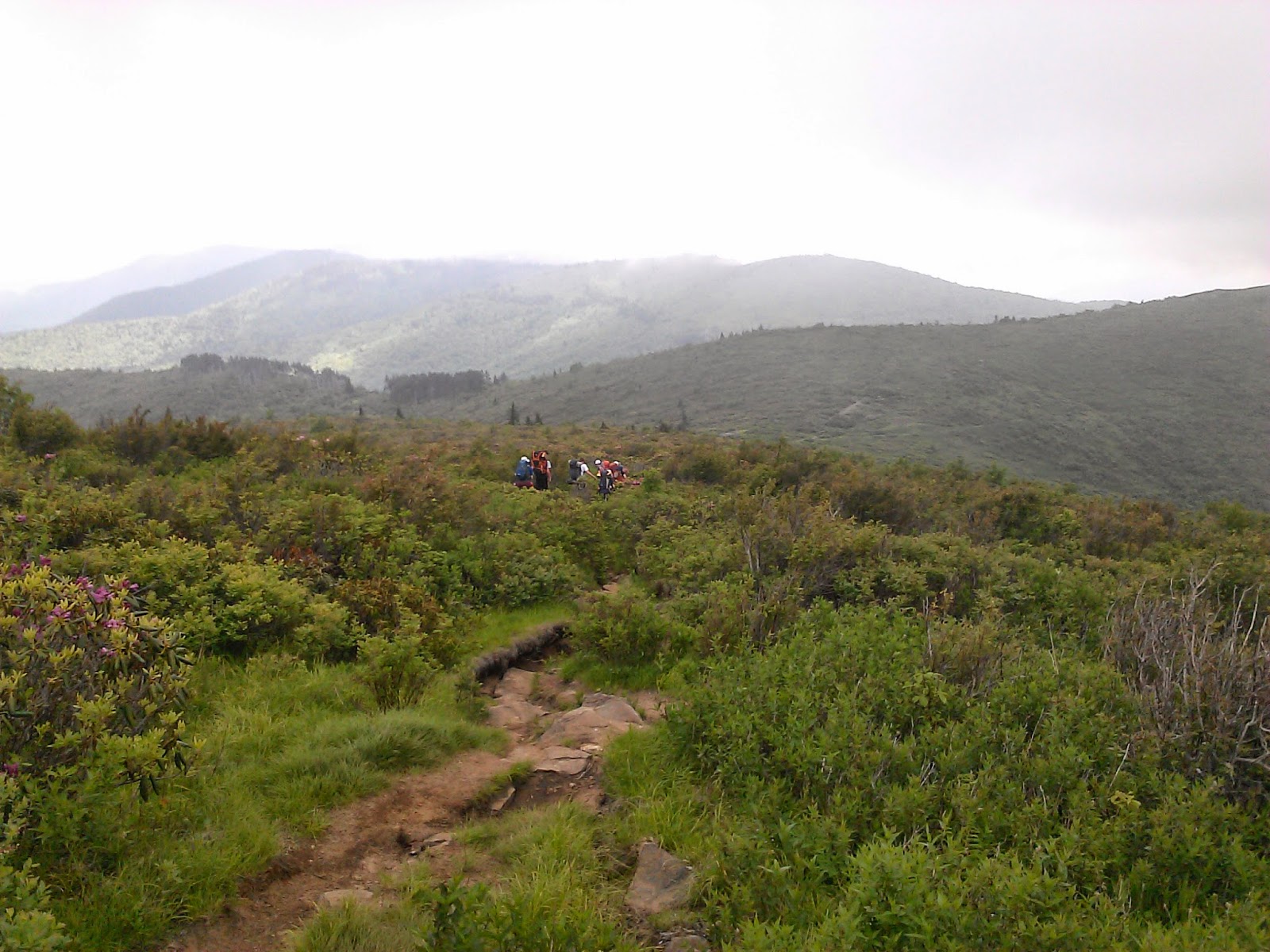
The trail goes up and over about 3 large balds.  My normal view was from in the back as youth won out over experience on this hike.


 We camped about 0.5 miles short of Shining Rock about 4 miles total.  The campsite was off of the trial by a few hundred yards up in a small grassy area.  It wasn't easy to find, but the Scouts on the trip had been here previously.


After setting up camp, we headed out to Shining Rock to check out the view.  Shining Rock is a large white rock outcropping.


The Clouds moved in and we headed back to camp for dinner under the rain fly.  The 1st night saw a fair amount of rain.  The high elevation (5800')  meant that it was pretty cool overnight.


The next morning the sun was shining, so the boys headed out to Shining Rock again.  I was going to hike a 6 mile loop off to the right of the trail, but I couldn't find it.  So I opted to continue out the Art Loeb trail after dropping by Shining Rock for a couple of photos.


 Along the trail were some nice flowers and views.


 The trail got pretty rocky and difficult after 2.5 miles.  I didn't have a good map, so I opted to turn back toward camp.


At camp, I dumped the pack and took some water and walked back toward the car on a different trail than the day before.  I ended up circling around the last bald we crossed on the way to camp.  I came back to camp on the jeep road.  After dinner, we headed out to Shining Rock for the sunset.


We packed up the next morning and headed out early.  Matt knew how to get down the Jeep road from the gap near camp and we hiked out on the Jeep road.  It was fairly level, but wasn't as enjoyable as the hike over the balds on the way in.  The trail ended on the road and there was about a 1 mile walk back to the car on the road. 

Awesome weekend with some excellent young men.

Thursday, June 5, 2014

Twentymile Loop - Lost Cove

Date: 6/4/2014
Distance: 15.8
New Map Miles: 7.5
Total Map Miles: 406.4

Today I hiked Solo in the Twentymile section of the park.  The goal was to pickup the Twentymile Loop Trail, the portion of Twentymile from the loop trail to the AT and if I had enough energy, the Lost Cove Trail.

The hike started on the Twentymile trail which appears to be an old road.  It is wide and easy to walk with very wide substantial bridges that cross the creek.  I happened upon a very large black snake on the edge of the trail, but other than that the walk was uneventful. After 0.5 miles, I took a left on the Wolf Ridge Trail.  I had hike the entirety of this trail back on New Years.  After 1.1 miles on this trail, the Twentymile Loop Trail leaves to the Right.  This trail is a classic single track path through the woods.  At places the undergrowth was encroaching into the trail, but for the most part the hike was pleasant.  At one of those overgrown areas, I bear was on the trail.  It took off into the woods, and I just held my ground and waited.  He was out of sight quickly and I continued down the trail.


 The loop trail climbed up to 2600' and then lost several hundred feet before returning to 2500' at the end.
 At this point, I rejoined the Twentymile trail and headed for the AT.  This was a steady climb up to 3600'.
 The trail had some nice orange azalea trees along the way.


 At the AT, the wind was howling through the gap.  It felt great as I had done lots of sweating on the way up.  It was blowing hard enough that I was afraid that a storm was approaching.

At this point, I had to decide if I had an additional 5.4 miles in me to go down the Lost Cove Trail and then backtrack to this point.  I decided to go for it, but quickly began to wonder if it was a good idea.  The Lost Cove Trail was very steep dropping quickly off of the ridge.  I was regretting the hike back up the entire way down.  This hike is probably best taken as a shuttle with a car at Fontana.

Half way down the mountain, I found another snake.

The last 0.5 miles of the trail had about 4 or 5 large stream crossings that I was able to hop rock with some effort, but I could imagine they would require boot removal during a wetter time.

 At the end of Lost Cove, I turned around and headed back up the mountain.  The end of the trail was at an elevation of 1800'.

I had seen this small reddish toad on the way down the mountain.  Surprisingly he or his brother were still sitting on the trail on the way back.

The hike back up to the AT was brutal.  At times I was stopping every few hundred yards because the climb was so steep.  The last mile was the worst.

Back at the AT, I sat down for a short while and noticed this ominous sign on the back of the trail marker.


 The hike back down Twentymile was a steady 5 mile descent to the parking area.  I had checked the elevation plots before the hike, but I hadn't really thought too much about the total.  By my calculation, I climbed about 4500' in the 3 big ascents.  Taking the heat into account (>85F), it was quite a workout.


Sunday, June 1, 2014

Mt. Collins to Clingmans Dome on the AT

Date: 6/1/14
Distance: 8.5 miles
New Map Miles: 4
Total Map Miles: 398.9

I got a late start today, so I decided to pick up a short segment on my map along the AT between the Mt Collins Shelter and Clingmans Dome.  I also had never hiked the Clingmans Dome Bypass trail, so I hiked that as well.

I didn't leave the house until 1:40, so it was about 3:30 when I arrived at the parking area where the Fork Ridge Trail hits the Climgmans Dome Road.  It was very foggy and it looked as if it had rained earlier in the day as the trail was pretty mushy with lots of standing water.


The trail began with a short climb of about 300', but all of that altitude and more was lost before the main climb began.  The main climb was about 1000'.  The trail was rocky in places and it was difficult to make good time.  About 1.5 hours into the hike, I reached the Clingmans Dome Tower.  The distance was about 3.7 miles.

The tower was fogged in, so there weren't many views.


I headed down the AT toward Fontana to find the Bypass trail.  It was a few tenths away from the tower.


The bypass trail dropped 400' and then there was a bit of a climb up to the parking lot at the end.

I dropped into the gift shop and finally purchased the little brown trail book.  I've been thinking that I should buy it, but just haven't had the chance.

I returned to the tower by going up the paved tower trail and then returning to Mt. Collins the way I came.  The rocky parts seemed a bit more treacherous in the downhill direction.


Made it back to the car a bit before 7:00 and got home about 9:00.