Friday, January 2, 2015

Cove Mountain Trail

Date: 1/2/2015
Distance: 17.2
New Map Miles: 8.5
Total Map Miles: 745.7

After waking up early and checking the weather, I decided to head for the mountains again this morning.  So far 2015 has started out great!  Two days and two hikes.

I had been saving Cove Mountain as I figured sooner or later it would show up on Meetup or I'd find someone to shuttle with me, but my options are dwindling, so I knocked it off today.

I started at the Sugarlands Visitor Center on the nature trail behind the building.  Just after the nature trail crosses a small creek, you take an immediate right towards Cataract Falls.  About 0.3 miles from the parking area, you reach the trailhead for Cove Mtn.

About 0.1 miles down the trail, you arrive at Cataract Falls.  It is a nice waterfall which is very easy to get to.
 The trail rock hops across the base of the falls and heads up the mountain.  The trail surface is just great.  The trail is wide with very few rocks or roots.  It does climb steadily for nearly the entire distance although there are 3 or 4 small dips once you've hike about 2/3rds of the trail.

 The trail hugs the park boundary, so there are several homes near the trail in the 1st several miles.


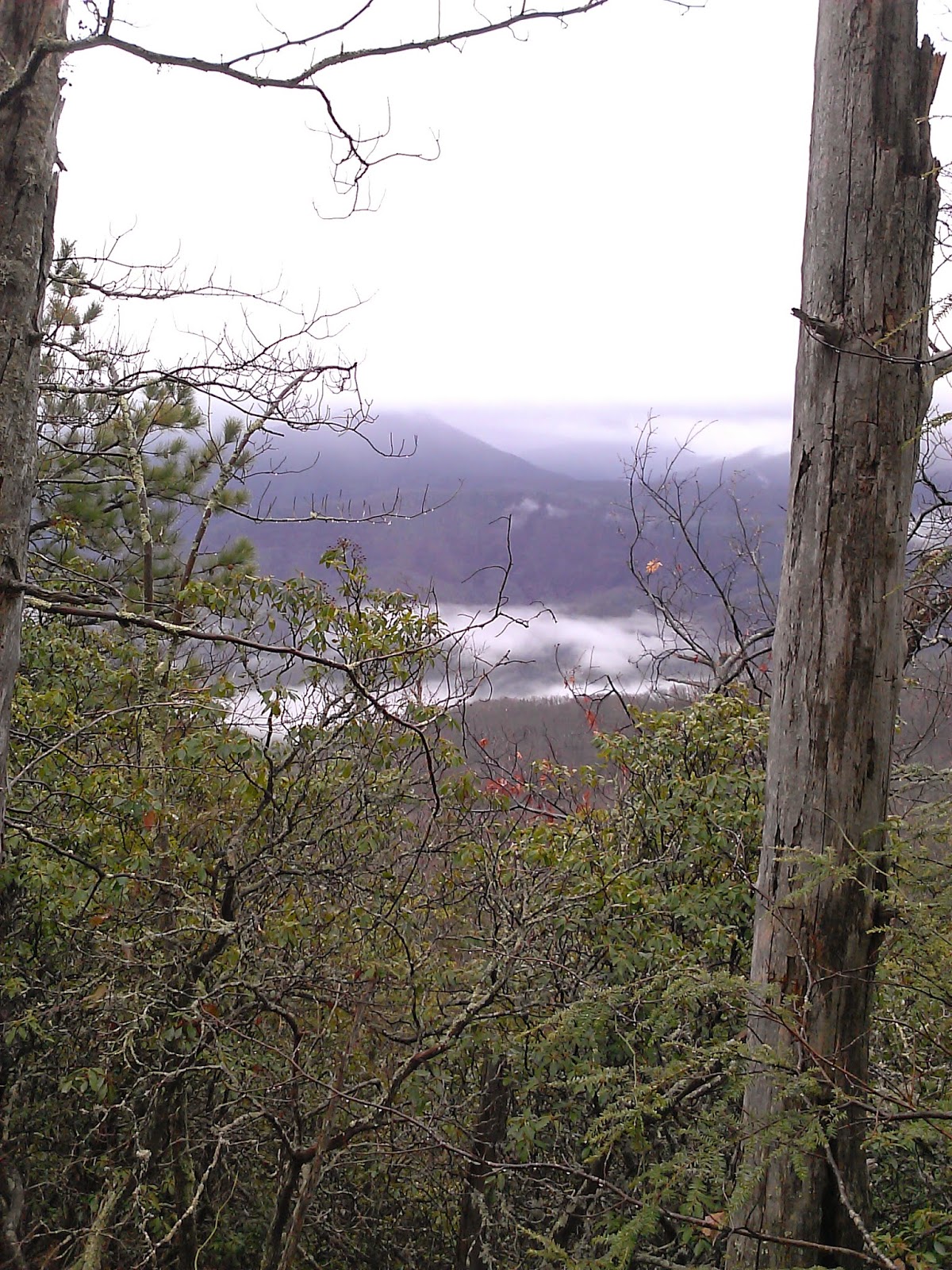
There are a few spots where there are some nice views.  On the way up, the clouds lifted a bit and I could enjoy them.


The last couple miles of the 8.4 is more desolate.  The trail does hug an old gravel road, but it appears to be rarely used.  I turned back at the Laurel Falls Trail sign as I had previously taken the 0.1 spur out to the tower when I hiked Laurel Falls.

 The fog moved in while I was up high and there were few views on the way down.  I also put on the rain jacket for the last 1/4th of the hike as it started to drizzle a bit.


I had heard talking on a loud speaker on the way up which I assumed was Ober Gatlinburg.  On the way back down, I paid more attention and spotted the ski resort.  I took a bit of an off trail trip over to the top of the lift.  This is the very top of the ski area.


Cove Mountain was a very nice trail with hardly any trail issues (mud, rocks, etc).  The climb did seem to go on longer than it should.

Thursday, January 1, 2015

Palmer Creek - Balsam Mtn

Date: 1/1/15
Distance: 15.6
New Map Miles: 6.4
Total Map Miles: 737.2

On this fine New Years Day, I started it off right by marking off the last of the Map Miles in Cataloochee. Today I met with Bill at exit 417 at 8:00.  He drove over and we hit the trail at 9:40.  We started the day on Pretty Hollow Gap Trail which leaves from Cataloochee just beyond the bathrooms and just before the big fields.

Pretty Hollow was an easy hike, but there were lots of other hikers on the trail.  ELK!!  We probably saw 10-12 and many of them were on the trail and we had to make noise to get them to move on.


 The Elk were distracting enough that the 1st 0.8 miles flew by bringing us to the Little Cataloochee Trail intersection. We continued anther 0.8 mile to where the Palmer Creek Trail leaves off to the left over a very nice foot bridge.

Pretty Hollow was an old road, but Palmer was the classic single track Smokies Trail.  Palmer climbs about 1800' over its 3.3 mile length.
There was one creek crossing on Palmer that we had a hard time with because the rocks were ice covered.  
Once we reached the end of Palmer, we turned right on the Balsam Mtn Road and walked about 0.6 miles on the road to the Balsam Mtn Trail.

Balsam Mtn was a little tougher than we expected.  It climbed another 700' or so, but had several downhill sections.  A few of the climbs felt worse than the 700' would indicate.  After 2.3 miles we reached the end and turned around to retrace our steps to the car.


 There were a few views through the trees along Balsam and Palmer


The hike was a moderate hike.  The trail was in pretty good shape.  It was a very nice day in the woods.


Monday, December 29, 2014

Noland Divide

Date: 12/29/14
Distance: 15.6
New Map Miles: 7.8
Total Map Miles: 730.8

Today I once again made the long drive to Deep Creek to mark off the lower 7.8 miles of the Noland Divide Trail.  The weather was foggy and drizzly in Tennessee, but just after crossing Newfound Gap, the weather cleared a bit.  By the time I was ready to hike, it was warm enough that I only wore a long sleeve hiking shirt and long hiking pants.  Not bad for the end of December.

The trail was in great shape as it made its way up the mountain.  The parking lot is at a bit under 2000'. Over the 1st 5 miles the trail climbs up to over 4500'.

 There were several places in the 1st 3 miles that you could see off of the trail into the surrounding valleys.  The fog started moving in though.

 At 3.5 miles, you reach the Lonesome Pine Overlook, when I got there it was very foggy, so I didn't take the short side trail.  Instead I  headed on up the mountain hoping for better weather on the way down.


The trail rises for about 5 miles and then dips down about 500' before a short climb up to the Pole Gap Intersection.  At this point, I turned around and headed back down the mountain.


Fortunately the clouds had lifted by the time I got back to the overlook, and the views were great.


The climb was substantial but the trail was great and the views were wonderful.  The drive home was awful, but fortunately, I'm now finished with the Deep Creek Trails, so I don't have to make that drive again!


Friday, December 26, 2014

Caldwell Fork - McKee Branch - Boogerman

Date: 12/26/14
Distance: 14 mi
New Map Miles: 9.6
Total Map Miles: 723

Today I drove over to Cataloochee to mark off Caldwell Fork, McKee Branch and Boogerman.  I had read that bridges were out on the Caldwell Fork Trail, so I arrived with some trepidation and was delighted to see a bridge at the 1st crossing which was visible from the parking lot.
Unfortunately, the 2nd crossing which is just before the Boogerman Intersection did not have a bridge.  It was quite refreshing as the outdoor temperature was just below freezing.

 
I hustled across and left the Chacos on until I reached the 3rd crossing.  When I saw a bridge, I immediately dried my feet and put my boots on.  The bridges kept coming until the 7th crossing which did not have a bridge.  Just up the creek to the left was a large tree across the creek, so I used it as a foot bridge.

 Caldwell Fork was is decent shape for a horse trail, but there were spots that were very rocky and looked like a horse trail.

There were a total of 11 significant creek crossings, but only 2 and 7 didn't have a bridge.  3.2 miles into the hike, the McKee branch trail turns off to the left.  McKee Branch wasn't in great shape. There is lots of erosion, so you spend lots of time dodging rocks and hiking in a ditch.  It also has a rather steep climb rising more than 1700' in 2.3 miles.  McKee terminates at Cataloochee Divide.  A trail continues across Cataloochee Divide that looks like an extension of McKee.  After a bit of lunch, I continued on down the trail until it arrived at a small cabin.


 The cabin is the John Ferguson Cabin. It was very small.


 The cabin is approximately 0.4 miles from Cataloochee Divide.  I turned around and went back up the hill for the return leg of the hike.  After going down McKee, I turned right on Caldwell until I arrived at the Boogerman Trail.


Boogerman starts out beside a creek on the right side with multiple homesites on the left side.  There were many rock walls that must have taken thousands of man hours to construct.


The most outstanding thing about Boogerman is that there are some very old large trees along the trail.  Boogerman apparently refused to  allow the lumber companies to log his land back before the park was formed, so we now have this trail with some great specimens.


 I finished off the day by crossing the creek on Caldwell Fork again and hiking another 0.8 miles to the car.  Didn't feel great today and had to take a couple of breaks on the way up the mountain, but it was nice to mark off another good piece of the map.


On the way out of Cataloochee, this Elk was grazing beside the road.