Saturday, September 26, 2015

Noland Divide - Pole Road - Martins Gap - Sunkota Ridge - Loop Trail - Indian Creek - Deep Creek

Date: 9/26/16
Distance: 19.1


Today I was back on the NC side of the park with the GSHAG group.  JD planned a "Heinous" hike and 4 of us were game for the challenge (Jenn, Ahmad, Annie and I).  We started the day about 9:20 in Deep Creek at the Noland Divide Trail.

Noland Divide climbs steeply up the mountain gaining about 2500' before losing about 500' and then a bit more climbing to the Pole Road Intersection.  Noland was a very enjoyable trail.  It was a steep climb, but was really beautiful.  About 4 miles in, you reach an open area with lots of views of the valley below.


The sign was gone, but a short trail leaves to the left just after this opening to the Lonesome Pine Overlook.  It is another good place to view the valley below.


 Up at the Pole Road Intersection, we had some lunch before heading down the mountain toward Deep Creek.  Last week there was very little color on the mountain, but this week there were many yellow leaves about.

 Pole Road Creek Trail loses 1800' over 3.3miles.  It has several creek crossings.  One was a little challenging.  I walked a big slippery log.  After making it over, I decided that it wasn't so smart.  Much of the trail was rocky or muddy or both.  It ends at the Deep Creek Trail.  We only spent 0.7 miles on Deep Creek before we reached Martin's Gap Trail.  The original plan was to go all of the way down Deep Creek, but on the drive over, JD decided that we should do Martins and the lower part of Sunkota.

Martin's Gap climbed 1000' over 1.5 miles.  It was tough late in the day.  This was  the "Heinous" part of the hike.  At least it was only 1.5 miles.  Up at Sunkota Ridge, we turned right and thought we were starting our downhill part of the hike, but Sunkota had a few more up hill sections before we finally started down.

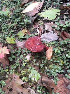
This cool mushroom was along this section of trail.


Sunkota was 3.8 miles from Martins Gap to the Loop Trail.  At the Loop trail, we turned left and hiked to Indian Creek (0.5 mi).

Indian Creek is a gravel road, so the hiking was easy from there.  Indian Creek Falls is along this trail.  My phone battery was dead, so I didn't get a photo, but it is like a slide down the mountain.  The 0.8 miles on Indian Creek went quickly as did the final 0.7 on Deep Creek.

We all piled in my car and drove over the JD's car at the Noland Trailhead.

We finished up about 5:00.  I got back home about 7:30.

All 19.1 miles were "new" miles on map #2, so it was a very productive day taking me over 300mi on Map #2.

Saturday, September 19, 2015

Bus Hike #3

Date: 9/19/15
Distance: 20.8
Bears: 3!

Today brought the 2nd bus hike in as many weekends, so I was up early again and headed for Clingmans Dome Road by 5:45.  We parked at the Noland Divide trail head and hit the trail by 8:00.  The day was very clear and it was just beautiful all day long.  It was a little warmer than last week.

Noland Divide was in great shape as it dropped off the side of the mountain.  Much of the Noland Divide trail was on a ridge after the initial drop. The 3.7 miles passed quickly as we lost about 1800'.

I did spot a medium sized bear jumping out of a tree and quickly running up and over the ridge, so that was exciting.


 The drop in elevation continued as we turned onto Noland Creek.  We covered the 5.1 miles on Noland Creek by 11:00 and took a seat at the picnic tables at Campsite 64.  It had several nice stone picnic tables and was close to the creek.  The elevation had dropped 3500' over the 8.8 miles.

There was a very nice and very new footbridge close to the campsite.


 After a small lunch, we started the climb on Springhouse.  JD, Annie and I all needed Springhouse up to Forney Ridge, so it was a good chance to get it by hiking in and out.  The trail was only 2.8 miles, but climbed 1500'.  There was lots of sweating and some complaining before we reached the Forney Ridge Trail.  We took a short break and headed back the way we came.

On the way down, we saw 2 bear cubs up in the tree.  We watched them and they watched us for about 10 minutes.  We were wishing that we had better cameras.


 Back at Noland Creek, we had a 2nd small lunch at the picnic tables before moving out down the trail.  From here out, the trail is a very gradual gravel road.


 It was 5.1 miles to the lake where we turned around and walked the 1 mile back to the parking lot.
 We made it out about 3:40 and the bus picked up right on time at 4:00.  We got back to the car about 6:00 and I was home by 8:00 with a nice Chinese to-go dinner.

Saturday, September 12, 2015

Forney Ridge - Springhouse- Forney Creek - Whiteoak - Lakeshore - Goldmine Loop

Date: 9/12/15
Distance: 19.1

Today I participated in a hike from Clingmans Dome to the Tunnel to Nowhere followed by a very long bus ride back up to the Dome.  The day started very foggy and rainy and cold up at Clingmans but by the time we were ready to hike, the rain stopped.  I was expecting a long day of hiking in the rain, however, the weather participated nicely and we had an entire day of dry hiking.

I had hiked Forney Ridge just a few weeks ago, but hiking it again was the best option to pick up the trails below Forney, so I set off down Forney again.  This time I had some nice company (Laura and Bill) to make a long day on the trail more enjoyable.  Bill and Laura were moving out, so Forney passed by quickly.  Andrews Bald wasn't quite as scenic as a few weeks ago due to the cloud cover.


After 5.6 miles of steady downhill hiking, we turned right on Springhouse heading for Forney Creek.
 This cool mushroom was along the trail.


 After 4.2 on Springhouse, we arrived at Campsite 71 at the intersection with Forney Creek.  71 is a very large campsite just along the creek.  It has an old Chimney and many good spots to camp.  We sat for a bit of lunch at the campsite as it was 11:30 and we'd all had breakfast very early.  I left the house about 5:45 and we had started hiking about 8:00.


 After a short lunch, I hiked the 1.2 miles up to Jonas Creek on Forney Creek Trail alone as Bill had already marked it.  At the Creek, I snapped a few photos and turned around to head for Lakeshore.

 Back at campsite 71, it was 1.3 miles down to Whiteoak where I met the others who had hiked the bottom 1.1 miles of Forney Creek.  Whiteoak is under construction and is only open on the weekends.  In addition Lakeshore between Forney Creek and the Tunnel is being renovated.  The trails were a muddy mess.
 It was slippery and nasty for the 1.8 miles on Whiteoak and the 1.3 on Lakeshore over to the Goldmine Loop Trail.  Goldmine on the other hand was just lovely.  It was a steep drop down to the lake, but along the way there was a nice old homesite in a field of flowers.


 A bit further, there is lake access.

 Another interesting mushroom was along the trail as well.


After 2 miles on Goldmine and 0.4 miles on the tunnel bypass trail, I arrived at the road at 3:10 and we had a nice long wait for the bus which picked up at 5:00.  The Bus got us back to the Dome about 6:30 and it was a 2 hr drive home from there.  Long day but very beautiful day in the woods.


Saturday, September 5, 2015

Hyatt Ridge - Enloe Creek

Date: 9/5/15
Distance: 10.8

This morning I drove over to the Hyatt Ridge trail in order to mark off Enloe Creek Trail.  It is a long drive.  I left the house about 6:45 and didn't start hiking until 9:30.

Hyatt Ridge is a big climb up the mountain rising 1400' in only 1.8 miles.  The trail looks like a road and is a little rocky in places.  After 1.8 miles, Enloe Creek leaves off to the left.


Enloe promptly gives up 800' over the 1st mile.  The trail drops down to the creek where a large bridge crosses the creek.


 The next 2.6 miles of Enloe climbs up to Hughes Ridge gaining 2200' on the way.  The creek parallels the trail nearly all the way up to to Hughes.


 I made it to Hughes about an hour and 50 minutes after starting.  I turned around and returned the way I came.
 I was back at Hyatt about 1:10 later and finished up with a total time of 3:40.
On the drive home, I opted to go through Maggie Valley instead of returning via 441 through Gatlinburg.   I was figuring that the traffic would be heavy since it was Labor Day weekend.  I somewhat regretted it as the traffic was slow in Cherokee and it seemed to take forever to get to the interstate and even longer to get on home.

I finished the hike about 1:10, but didn't get home until 4:00.