Distance: 15mi
Today I hiked with the GSHAG Meetup Group. The hike left from the very end of the Tremont Road. I didn't realize that the road was gravel, so the drive after turning into Tremont was longer than I expected.
Middle Prong is an old road, so the trail is wide and rises rather gradually. One of the 1st features of the hike is a very nice cascade that covers about 100 yards
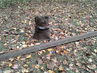
 It probably isn't a permanent marker, but this was on the right side of the trail marking a path over to an old car.
 Farther down the trail, an old chimney was on the left.
A bit before the end of Middle Prong, a trail leaves off to the right for a short distance to a water fall.

The falls is actually a series of falls. In the pictures below, I climbed down through the rhododendron to the bottom to take some photos. The water fall above is at the very top of the series of 3 falls.
The trail continues up as we turned on Lynn Camp Prong and then Miry Ridge. It was quite a climb, but didn't seem too steep to me. We probably climbed for close to 10 miles and then came down in only 5. The total climb was 2600 ft, so it is a long challenging hike.
Just as Panther Creek gets back to Middle Prong there was a creek crossing. Several in the group decided to remove their boots and wade. I just hop rocked across, but I was nervous. The hikers in the group indicated that the water is often higher and there is no option other than wading.
Back on Middle Prong for the last 2.3 miles to the car, I noticed this cool rock formation on the left. Didn't notice it on the way up.


No comments:
Post a Comment