Saturday, October 26, 2013

Bote Mountain - West Prong - Schoolhouse Gap

Date: 10/26/2013
Distance: 11.5mi

Today I needed to be back in Knoxville before 2:00, so I headed out early (6:45).  I turned towards Cades Cove and stopped at the 1st trail on the right.  Across the road  and down a hundred yards was the trailhead for the Bote Mountain trail.  I started on this trail as I had not hiked the section from the road to Finley Cane.  It was a cold morning for October (high 20's).  I started with a couple of base layers and my thin fleece.  About 10 minutes in I gave up and put on my thick fleece and my ski gloves.  The Bote mountain trail is an old road, so it is wide and on this section was a fairly good surface.  It also isn't quite as steep as the part that is along the ridge.

I quickly warmed up and before reaching the ridge (1.2mi) I was back to the thin fleece and no gloves. Up on the ridge the sun was just coming over the far ridge.


 At the ridge I turned right continuing on Bote Mountain.  About 0.3 miles after the turn (1.5mi total), I reached the junction with Finley Cane Trail.  A this point I turned around as I had previously hiked the rest of Bote Mountain.  After backtracking the 0.3 miles, I continued straight on the West Prong Trail.

The beginning of the West Prong Trail, had a relatively large drop in elevation.   Eventually there was a backcountry campsite and a bridge over a creek.


There was also a very small stream crossing shortly after the campground.  Many leaves had fallen in the section between the campground and Tremont, so there was a nice yellow carpet in a few places.  Most of the trees in this area were Tulip Poplars which were very tall and straight.  From the Bote Mountain trail to the campground, about 400' of elevation is lost.  On the section from the campground to Tremont, the trail rises about 600' and then loses it all before the end.


The West Prong trail ends at Tremont after 2.7 miles.  At this point I turned around and headed back.  There are 2 obvious trails that leave this trail, but were unmarked and not on the map.  I followed the 2nd one for 0.25 miles.  The trail was maintained, but I turned around before it reached anything interesting.

The sun was shining bright on the ridge by the time I got back to the Bote Mountain Trail.


 I headed back down Bote Mountain to the car.  I lightened the load in the backpack and then headed up Schoolhouse Gap to pick up the 1.1 miles from the road to Turkeypen.  This trail is also a wide road with a rather gradual rise.
The 1st part of the trail has a small stream on the side.  Today it was covered with leaves floating on the water.  

 It was a very enjoyable day in the woods.
Start:  8:00
Finley Cane:  8:40
Tremont: 9:40
Start Schoolhouse Gap: 11:40
Finish: 12:10

Saturday, October 19, 2013

Middle Prong - Lynn Camp Prong - Miry Ridge - Panther Creek

Date: 10/19/13
Distance: 15mi

Today I hiked with the GSHAG Meetup Group.  The hike left from the very end of the Tremont Road.  I didn't realize that the road was gravel, so the drive after turning into Tremont was longer than I expected.

Middle Prong is an old road, so the trail is wide and rises rather gradually.  One of the 1st features of the hike is a very nice cascade that covers about 100 yards


It probably isn't a permanent marker, but this was on the right side of the trail marking a path over to an old car. 


 Farther down the trail, an old chimney was on the left.


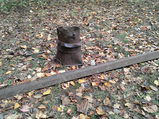
There was also a rail and an old bucket on the side of the trail.


A bit before the end of Middle Prong, a trail leaves off to the right for a short distance to a water fall.


 The falls is actually a series of falls.  In the pictures below, I climbed down through the rhododendron to the bottom to take some photos.  The water fall above is at the very top of the series of 3 falls.

 The trail continues up as we turned on Lynn Camp Prong and then Miry Ridge.  It was quite a climb, but didn't seem too steep to me.  We probably climbed for close to 10 miles and then came down in only 5.  The total climb was 2600 ft, so it is a long challenging hike.


At the very top of the climb, there is an opening with amazing views.


Just as Panther Creek gets back to Middle Prong there was a creek crossing.  Several in the group decided to remove their boots and wade.  I just hop rocked across, but I was nervous.  The hikers in the group indicated that the water is often higher and there is no option other than wading.
Back on Middle Prong for the last 2.3 miles to the car, I noticed this cool rock formation on the left.  Didn't notice it on the way up.


Charlies Bunyon

Date: 10/18/13
Distance: 8.1 mi

Today we hiked out to Charlies Bunion.  The weather was perfect and the hike was very enjoyable.  Near the highest altitude we reached (just before Sweat Heifer trail) we heard a very loud noise off to our right.  It sounded like a helicopter.  It is impossible to see in the photo, but the noise came from a bird sitting on the log on the ground.  It was about the size of a chicken.   It may have been a grouse based on what some people thought based on the description.


The views at the Bunion were great.


Frozen Head - Panther Branch - North Old Mac - South Old Mac - Spicewood

Date: 10/4/13
Distance: ~10mi

Date: 10/11/13
Distance: ~9mi

The weather was spectacular on two Fridays in a row, so I left work about noon on each day and headed over to Frozen Head to do some hiking.  I've hiked these trails in the past, so I'll keep this short.
On the 1st hike, I went up Panther Branch to North Old Mac to South Old Mac.  On the 2nd Friday, I went up Old North Mac and down Spicewood.

There was hardly any water in the falls along Panther Branch.  Last time the falls were nice, but today just a trickle.

I went to the tower both days.  Views were amazing